Introduction to Trekking Route Optimization
Trekking route optimization refers to the meticulous process of selecting and enhancing paths taken during long-distance hikes. The significance of this concept cannot be overstated, particularly for avid outdoor enthusiasts who seek to maximize their hiking experience. Efficient route planning serves several pivotal purposes, the foremost being the enhancement of safety, efficiency, and overall enjoyment during long treks.
One of the primary benefits of optimizing hiking routes is the increased safety it provides. By carefully evaluating terrain, weather conditions, and potential hazards, trekkers can make informed decisions that minimize risks. For instance, in complex landscapes, optimized routes can guide hikers away from dangerous areas, ensuring that journeys are not only enjoyable but also secure.
In terms of efficiency, trekking route optimization allows hikers to conserve energy and time, making their journeys more productive. Well-planned routes take into consideration the most effective paths, reducing redundancy and unnecessary exertion. This is especially crucial in long-distance hikes, where energy conservation can significantly impact the overall experience and success of the trek.
The enjoyment factor also plays a vital role in trekking route optimization. A well-curated path enables hikers to appreciate the natural beauty of their surroundings without the stress of navigating through unfamiliar or challenging routes. Incorporating scenic views and points of interest can greatly enhance the trek, fostering a deeper connection with nature and providing an enriching experience.
As we delve further into this blog post, we will explore various techniques and technologies that aid in effective route optimization. This exploration will provide insights into modern tools and methods used by trekkers, fostering a deeper understanding of how optimally planned hiking routes can significantly elevate the trekking experience.
Understanding Key Factors in Route Planning
When planning a long-distance hiking trail, several critical factors come into play, all of which significantly influence the trekking experience and the optimization of the route. The terrain type is paramount; it is essential to consider whether the trail is predominantly flat, hilly, or rocky, as each variation presents unique challenges and requires different levels of skill and preparation. For example, a rocky path may slow down progress, necessitating more time to navigate safely.
Elevation changes are another crucial aspect of route planning. A trail with steep ascents and descents can greatly affect a hiker’s physical endurance and overall experience. Elevation significantly influences fatigue levels, and if high elevations are involved, one must also account for potential altitude sickness. Optimizing a route to include manageable elevation profiles can enhance safety and enjoyment.
Water sources along the route are vital for hydration and should be carefully mapped out. Running out of water can lead to severe complications, especially on longer hikes. Hikers must be aware of the locations of reliable water sources and their accessibility. Similarly, understanding weather conditions can impact route selection and safety; adverse weather can lead to treacherous conditions, making a previously viable path hazardous.
Lastly, the presence of clear and well-marked trails is crucial. Good trail markings help ensure that hikers remain oriented and on the right path, minimizing the chances of getting lost. Each of these elements must be thoughtfully considered to enhance the hiking experience and facilitate effective route optimization. Together, these factors contribute to creating a safe, enjoyable, and efficient trekking route that caters to the needs of long-distance hikers.
Tools and Technologies for Route Optimization
When it comes to optimizing trekking routes for long distance hiking trails, various tools and technologies play a critical role in enhancing the hiking experience. Among the most popular are GPS devices, smartphone applications, and online mapping tools, each offering unique features designed to assist hikers in route planning and navigation.
GPS devices offer precision in location tracking, ensuring travelers remain on course even in challenging terrains. Many of these devices come preloaded with topographic maps and can store multiple routes, enabling hikers to switch paths easily based on real-time assessments of weather or trail conditions. An advantage of dedicated GPS units is their robustness and long battery life, which can be particularly beneficial during extended treks.
Smartphone apps have gained popularity due to their convenience and accessibility. Applications such as AllTrails and Gaia GPS not only provide detailed maps but also allow users to download routes for offline use, proving useful in areas with limited cell service. These apps often include user-generated content and reviews, which can offer insights into trail conditions and tips from fellow hikers. Additionally, many apps integrate features such as elevation profiles, estimated times for completing trails, and customizable waypoints, making them versatile tools for trek optimization.
Online mapping tools like Google Maps and specialized platforms such as Komoot enable users to plan their routes comprehensively. Features such as drag-and-drop customization help hikers create personalized trails, while reviewing topographic overlays allows for better understanding of elevation changes. The strength of these tools lies in their ability to merge navigational ease with planning, allowing for enhanced strategic decisions based on desired hiking intensity and scenery.
In summary, whether using a dedicated GPS device, downloading a smartphone app, or utilizing online mapping tools, hikers have a plethora of options available for optimizing their trekking routes. Each of these technologies contributes to a safer and more enjoyable hiking experience by facilitating better route planning and navigation.
The Role of Trail Data in Optimization
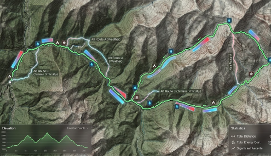
In the realm of long-distance hiking, optimizing trekking routes is paramount for ensuring a safe and enjoyable experience. Central to this optimization process is the utilization of trail data, which provides essential insights into various aspects of the hiking landscape. Topographic maps, for instance, serve as a valuable resource in understanding elevation changes, terrain types, and water sources along the route. This geographical information allows hikers to plan their trips more carefully, identifying challenging ascents or descents, thereby enhancing safety and comfort.
Furthermore, trail reviews play a crucial role in the decision-making process. Hikers often share their experiences regarding the trail conditions, which can fluctuate due to weather, maintenance, or natural events. By analyzing these reviews, prospective trekkers can gauge the difficulty level of a given trail, the presence of obstacles, and the general accessibility, tailoring their plans to align with their abilities and preferences.
User-generated content, such as photographs and GPS tracks, can also be invaluable. These resources often highlight the actual conditions of the trail, including varying weather patterns and seasonal changes that may not be documented elsewhere. By leveraging this content, hikers can make informed decisions about when to embark on their journeys, as well as which routes are most suited to their hiking goals.
Collecting trail data is essential for route optimization. Hikers can gather this information through various platforms, including hiking forums, social media groups, and trail-specific websites. By engaging with the hiking community and synthesizing their insights, trekkers can create a comprehensive data pool that enables them to evaluate and choose the most efficient and safest trails available. Overall, the integration of trail data into planning processes enhances route optimization, significantly enriching the long-distance hiking experience.
Creating Custom Hiking Routes: Step-by-Step Guide
Creating custom hiking routes is an essential part of preparing for a long-distance trek. This meticulous process allows hikers to tailor their journeys according to personal preferences, fitness levels, and scenic interests. Below is a step-by-step guide that can help outdoor enthusiasts design their optimal trails.
The first step in crafting a unique hiking route is to assess your fitness level. Understanding your endurance and physical capabilities is crucial, as it will influence the distance, elevation, and terrain type you can comfortably handle. Consider your past experiences with hiking and outdoor activities to determine what challenges may be appropriate for you. It is advisable to maintain a fitness journal that tracks your progress and helps set realistic goals.
Once you have assessed your fitness level, the next step is to choose suitable trails. Research various hiking routes that align with your physical capabilities and interests. Utilize online platforms that offer trail reviews, photos, and maps, as these resources provide valuable insights into the trail’s difficulty, length, and scenery. Ensure to select routes that not only match your abilities but also offer the natural beauty and experiences that you desire from your hike.
After selecting the trails, it is important to utilize technology and data to develop a personalized route. Several mapping applications allow hikers to create and customize their routes, incorporating waypoints, elevation changes, and other key details. Familiarize yourself with GPS devices and mobile apps that can assist with real-time tracking during your hike. Additionally, reviewing current weather conditions and local wildlife reports can enhance your planning process, ensuring your route is safe and enjoyable.
By following these steps, hikers can create a custom hiking route that caters to their unique needs, leading to a fulfilling and memorable experience in nature.
Evaluating Difficulty Levels and Trail Conditions
When considering long-distance hiking trails, understanding the difficulty levels and current trail conditions is paramount for safe and enjoyable trekking. Trails are generally rated based on their difficulty, which often includes factors such as elevation gain, terrain type, length, and technical challenges. Common rating systems categorize trails into classifications ranging from easy to strenuous, assisting hikers in making informed decisions based on their skill level and physical fitness.
Seasonal changes can significantly alter trail conditions. For instance, snow, rain, or high temperatures can transform a mild hike into a challenging adventure. During spring, melting snow and rain can lead to muddy paths and concealed hazards. Conversely, trails during fall may present dry and stable conditions, but increased leaf cover can obscure trail signs and hazards. Consequently, it is essential for hikers to stay updated on weather forecasts and trail reports prior to their journey, as these factors may influence route optimization.
Additionally, potential hazards such as rocks, roots, water crossings, and wildlife encounters can vary dramatically based on the specific route and season. Assessing these conditions can aid hikers in determining not only their own capabilities but also the essential gear or preparations required for the hike. Tools such as detailed trail maps, guidebooks, or online resources can provide valuable insight into what hikers might face on any particular trail.
Taking into consideration these evaluations of difficulty levels and trail conditions equips hikers with the knowledge necessary to choose appropriate trails and enhance their trekking experience. Implementing an informed approach to trail selection will ultimately support safer and more enjoyable long-distance hiking adventures.
Safety Considerations in Route Optimization
When embarking on long-distance hiking trails, safety must be a top priority during the process of route optimization. Hikers should begin by assessing potential risks associated with their chosen paths. This includes evaluating terrain difficulties, weather conditions, and wildlife presence, as these factors can significantly impact the safety and overall hiking experience.
It is crucial to prepare for emergencies by equipping oneself with essential safety gear and supplies. A well-stocked first aid kit, adequate water, food supplies, and navigation tools are integral components of any hiking pack. Additionally, hikers should familiarize themselves with the trail conditions and potential hazards that may arise, such as slippery rocks, steep ascents, or sudden weather changes.
Furthermore, informing someone of your hiking plans is an essential safety measure that should not be overlooked. Designating a responsible individual to be aware of your route and expected return time can be invaluable in case of emergencies. This practice not only provides peace of mind but also ensures that assistance can be deployed swiftly if needed.
Another key aspect of safety is maintaining communication while on the trail. Carrying a fully charged mobile phone, a GPS device, or a personal locator beacon can enhance safety during long-distance hikes. Knowledge of the area, including locating nearby shelters or emergency services, adds an additional layer of preparedness.
Ultimately, prioritizing safety considerations in route optimization enriches the hiking experience and minimizes risks. By taking the time to assess risks, prepare for emergencies, and maintain effective communication, hikers can enjoy the beauty of long-distance trails while ensuring a secure journey.
Case Studies: Successful Route Optimization Examples
Over the years, numerous trekkers have undertaken the task of optimizing trekking routes along long-distance hiking trails. These real-world scenarios illustrate the efficacy of thoughtful planning and adaptation to the surrounding environment. One such example is the Pacific Crest Trail (PCT) hikers who, in 2015, faced an unprecedented snowpack due to a particularly harsh winter. Many hikers reported difficulties navigating the original trail, leading to a group effort in optimizing routes that steered clear of dangerous snow-laden sections. By collaborating through social media platforms, they shared updates in real time, enabling them to discover and follow alternative paths that were both safer and more scenic.
Another noteworthy case occurred on the Appalachian Trail (AT), where a combination of heavy rainfall and eroded pathways prompted a team of volunteer trail maintainers to introduce a series of route optimizations. They identified areas where bogs formed and rerouted the trail to higher ground, significantly improving the hiking experience. By actively engaging the hiking community, the maintainers ensured that updates were widely circulated, allowing long-distance hikers to confidently navigate these new sections. This collaborative optimization process underscored the importance of not only environmental factors but also community input in making necessary adjustments.
A further example comes from hikers on the Torres del Paine circuit in Chile, who faced weather challenges and trail closures due to landslides. By utilizing GPS tracking and user-generated content, trekkers were able to share vital information about trail conditions and closures. This allowed others to optimize their routes to favorite viewpoints and avoid hazardous areas effectively. These case studies demonstrate the potential for successful route optimization through community effort, innovative technology, and the dedication of individuals committed to enhancing their hiking experiences.
Conclusion and Future Trends in Trekking Route Optimization
In assessing the state of trekking route optimization for long-distance hiking trails, several key points have emerged. The integration of technology in route planning has transformed the way hikers approach their journeys, allowing for the identification of optimal paths that enhance both safety and enjoyment. From the use of GPS and mapping applications to community-driven platforms where trail conditions are shared, advancements in digital tools continue to refine the trekking experience. This optimization not only benefits the trekkers in terms of route efficiency but also promotes environmental sustainability by guiding hikers away from vulnerable ecosystems.
As we look to the future, it is clear that technology will play an increasingly central role in trekking route optimization. Emerging trends such as the use of artificial intelligence and machine learning algorithms indicate a shift towards more personalized trekking experiences. These technologies can analyze a hiker’s preferences, physical capabilities, and historical data to recommend tailored routes that optimize both challenge and enjoyment. Additionally, smart wearables equipped with health monitoring features are likely to become commonplace, enabling trekkers to receive real-time feedback on their physical condition, thereby enhancing safety and comfort on long trails.
Furthermore, the continued development of augmented reality (AR) and virtual reality (VR) tools holds the potential to revolutionize trail exploration. Imagine being able to preview a hiking trail in an immersive manner before setting out, thus allowing trekkers to make informed decisions based on visual and geographical insights. As outdoor enthusiasts become more interconnected through social media and digital forums, community engagement will also shape the future of trekking routes, fostering collaboration in trail management and enhancement.